Where Is Amsterdam - Location of Amsterdam on the World Map
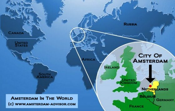
Where is Amsterdam located on the world map, you might be wondering? Amsterdam is the capital city of the Netherlands, and this country is located in North-West Europe between Germany in the east, Belgium in the south, and the North Sea in the north and west.
On the map, Amsterdam is located at 52°22' north latitude and 4°53' east longitude (meaning over 52 degrees north of the Equator, which is 0 degrees, and 4 degrees east of London, which was once defined as 0 degrees).

The Netherlands are sometimes popularly called 'Holland', but actually Holland refers to the western provinces of North-Holland and South-Holland within the Netherlands (who were politically dominant over the others). The inhabitants of the Netherlands are called the Dutch.

Distances To Amsterdam From Abroad
How far is Amsterdam from some major world capitals? Here are the details. The flying times refer to commercial airliners, and are averages.
| Stretch | Kilometers | Miles | Nautical Miles | Flying Time (Aprox.) |
| Amsterdam - New York (NY, USA) | 5,870 | 3,648 | 3,170 | 8.5 hours |
| Amsterdam - Los Angeles (CA, USA) | 8,964 | 5,570 | 4,840 | 11 hours |
| Amsterdam - London (UK) | 356 | 221 | 192 | 1 - 1.5 hours |
| Amsterdam - Canberra (Australia) | 16,625 | 10,330 | 8,977 | (no direct flights) |
| Amsterdam - Cape Town (South Africa) | 9648 | 5995 | 5209 | 11.5 hours |
| Amsterdam - Moscow (Russia) | 2,157 | 1,340 | 1,165 | 3.5 hours |
| Amsterdam - Beijing (China) | 7,844 | 4,874 | 4,235 | 10 hours |
| Amsterdam - New Delhi (India) | 6,371 | 3,959 | 3,440 | 8 hours |
Where Is Amsterdam Within The Netherlands?

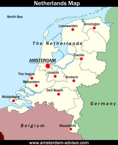
Amsterdam is located in the province of North-Holland. The provincial capital of North-Holland is not Amsterdam, though, but Haarlem. (Harlem in New York is named after Haarlem, because of the Dutch founders of New York.)
Sometimes foreigners mistakenly think that The Hague is the capital of the Netherlands, because the Dutch government is located there. Amsterdam is clearly the cultural capital of the Netherlands, though: it has the biggest museums, the leading orchestras, two universities, most national newspapers and a thriving art scene. It's a popular tourist destination: 4 million tourists annually come to see the old city center's architecture and canals, visit the museums and experience the liberal, international culture.
Distances To Amsterdam Within The Netherlands
Here are the distances between some bigger Dutch cities/towns and Amsterdam, and the approximate driving time by car.
| Stretch | Kilometers | Miles | Driving Time (Aprox.) | By Train |
| Amsterdam - The Hague | 60 | 37 | 40 mins | 50 mins |
| Amsterdam - Rotterdam | 75 | 47 | 50 mins | 60 mins |
| Amsterdam - Utrecht | 45 | 28 | 35 mins | 30 mins |
| Amsterdam - Arnhem | 100 | 62 | 65 mins | 70 mins |
| Amsterdam - Zwolle | 115 | 71 | 70 mins | 75 mins |
| Amsterdam - Groningen | 185 | 115 | 110 mins | 140 mins |
| Amsterdam - Maastricht | 215 | 133 | 125 mins | 150 mins |
| Amsterdam - Middelburg | 170 | 105 | 120 mins | 150 mins |
Related Pages:
- General Amsterdam information
- More Amsterdam facts
- The basics of Amsterdam travel
- From Where is Amsterdam? back to Amsterdam Advisor
Skip the Lines!
Book your museum, tour and canal tickets here with a discount and without the (long!) waiting lines!
We are able to offer this through an Amsterdam ticket broker whith exclusive deals with all major Amsterdam attractions.
About Us
Amsterdam-Advisor.com is written by local residents who once arrived in Amsterdam for the first time, just like you...
Read more
